Do I Need a Permit?
What work does and does not require a permit?
Section 105.1 of the Florida Building Code states that a permit is required to construct, enlarge, alter, repair, move, demolish or change the occupancy or occupant content of a building or structure or to erect, install, enlarge, alter, repair, remove, convert or replace any electrical, gas, mechanical or plumbing system, the installation of which is regulated by the technical codes.
Work that requires an inspection to verify compliance with the applicable technical code requires a construction permit.
Separate electrical, mechanical or plumbing permits may be required even if a building permit is not required. Following are examples of work that does and does not require a permit. These examples are not all inclusive and there will be situations that are not addressed here. If you have a question as to permit requirements, call our Bartow office at (863) 534-6080 and ask to speak with a plans examiner.
Work Requiring a Construction Permit
- Construction or demolition of any building or structure regardless of size.
- All new construction, including additions and any alterations, renovations or remodels involving structural elements or involving any electrical, plumbing, fuel gas, fire systems, pollutant storage tanks, on-site underground utilities, signs or mechanical systems.
- Alterations, renovations, remodels or modifications to any commercial structure affecting occupancy classification, means of egress, fire resistance ratings or handicap accessibility.
- The installation, alteration, replacement, extension or repair of any irrigation, electrical, plumbing, mechanical work, fuel gas, fire systems, solar systems or any associated electrical work (low voltage) including the change out of A/C equipment, electrical service changes or the addition of electrical outlets or circuits.
- Conversion of any non-habitable space to habitable space including the enclosure of garages, carports, porches or similar structures and the replacement of screening or vinyl windows with glass or solid walls.
- Screening of any space, which requires structural or infill framing to be added.
- All foundation remediation work to assure that an engineer is overseeing the work.
- Any change in occupancy as defined by the building code.
- Commercial and residential docks, piers, sea walls, boathouses, bulkheads and boat ramps.
- All masonry walls and fences with masonry pilasters. All solid fences over eight feet high.
- Retaining walls required for structural support, protection or erosion.
- Decorative retaining walls. Call (863) 534-6080 and ask for a plans examiner for information.
- Concrete slabs adjacent to a principal or accessory structure, intended for support of a structure, elevated slabs, sidewalks and portions of driveways in the right of way or within the minimum setbacks. Note: All slabs shall meet minimum setbacks from property lines and easements, except sidewalk and driveways. Building Code and Land Development Code drainage requirements shall be met.
- Pavers installed within the required setbacks or adjacent to structures. Note: Shall meet Building Code and LDC Requirements.
- Tents over 900 square feet or larger for public assembly or use or having electrical lighting.
- Pre-manufactured storage buildings, residential buildings and commercial buildings.
- Additions, repairs, alterations or accessory structures to mobile homes or park trailers. Owners of a mobile home or park trailer situated on a rented lot will not be able to permit additions as owner builders without notarized landowner consent.
- Mobile home and park trailer set-ups. Owners of a mobile home or park trailer situated on a rented lot will not be able to permit additions as owner builders without notarized landowner consent.
- In ground swimming pools and spas. Above ground swimming pools and spas more than 24″ deep.
- Pool/spa repairs, renovations, demolitions and remodels involving structural elements, electrical, gas, solar, geothermal work or additional equipment.
- All re-roofing including mobile homes and park trailers and including installation of insulated roof coverings.
- Decks, walkways, platforms, stairs and landings. All shall meet setbacks and shall not encroach in easements.
- All carports or similar structures with rigid roofs.
- All flagpole foundations and poles greater than 50 feet high.
- Replacement of skylights, windows and doors including garage doors.
- Installation or replacement of vinyl or acrylic windows.
- Plumbing re-pipes and water heater change outs.
- Installation or replacement of security bars or permanently installed window and door shutters.
- Siding and soffit replacement or installation.
- Handicap ramps require a permit and must meet setbacks.
- Tree houses require a permit with sealed engineered plans. Exception: residential tree houses that meet the following criteria:
1) Tree houses with maximum floor area of 32 square feet.
2) May have up to a 30 inch knee wall.
3) Shall meet minimum LDC Accessory Structure setback requirements.
4) Shall be totally supported by tree.
5) Shall have no electrical or plumbing.
6) Shall have no roof.
7) Maximum of one tree house per residential lot.
Work Not Requiring A Construction Permit
- Minor roof repairs – less than 25 square feet.
- Replacement of screening with like material in an existing structure.
- Interior remodels, interior renovations or interior repairs on ANSI units or RVs.
- Minor electrical, plumbing, mechanical repairs only, no extensions or modifications.
- Chain link fences of any height and stockade fences up to eight feet high. Check Polk County Land Development Code for prohibited materials for fencing.
- Structures intended for storage use only (prefabricated and of a “Closet” use). You may reach in only, not walk-in. These exempt structures are limited to a maximum 5 ft. height (mean height), 50 sq. ft. maximum area and a maximum 250 cubic ft. with no electrical or plumbing.
Steps to Permitting
Step 1:
Submit Application Online on the Accela Citizens Portal
Basic information needed for the building permit application will include:
- Owner’s name
- Property address and Parcel ID Number (can be obtained from the Polk Property Appraiser’s website)
- Directions to the property and gate code (if applicable)
- Description of work (what you’re planning to do)
- Total value of work
Please note, all information listed above must be provided and additional information may need to be provided depending on the type of permit being requested.
Step 2:
Upload or deliver required plans and supporting plan documentation (pay applicable fees) construction documents, a statement of special inspections and other data shall be submitted with each application for a permit. The construction documents shall be prepared by a registered design professional where required by Chapter 471, Florida Statutes or Chapter 481, Florida Statutes.
At a minimum, two sets of the following shall be submitted for commercial, industrial, multi-family, trade, one and two-family residential:
- Individual Lot Plot Plan
- Proof of Approved Site Construction Plan (Level 2)
- Foundation Plan
- Floor/Roof Framing Plan or Truss Layout
- All Exterior Elevations
- Floor Plan
Step 3:
Have plans reviewed and approved
Step 4:
Upload documents required prior to permit issuance (pay applicable fees)
The items below are not required prior to plan review; however, they must be submitted prior to any permit issuance:
- Construction Waste/Setback Form
- Primary Contractor Info
- Sub-Contractor Info
- Additional documents may be required based on scope of work, type of application – applicant (owner/builder, contractor) will be notified of other required documents, i.e., flood certificate, letter of authorization, etc.
Step 5:
Permit issued. After permit issuance, a recorded Notice of Commencement (NOC) or other documents may be required prior to inspections.
Caution: Per Florida Statutes 125.022 and 166.033, the issuance of this Building Permit does not exempt the applicant from obtaining all permits or approvals required by State or Federal agencies. Proof of said permits must be provided to the Building Division prior to commencement of construction. Effective July 01, 2012
For questions or additional help, please call (863) 534-6080 and ask to speak to the Permit Tech On Call.
Fees
Building and Permitting Construction Fees
Building and permitting construction fees are listed in Construction Fees Resolution 17-025 which took effect on July 3, 2017. All construction permit fees are due at time of permit issuance.
Impact Fees Rate Schedules
On March 21, 2023, the Board of County Commissioners adopted new Transportation Impact Fees. The new rates went into effect on July 1, 2023.
Single Family Detached (Per Dwelling)
| Impact Fee | Ord 2023-1959
July 1, 2023 |
Ord 2023-1959
July 1, 2024 |
Ord 2023-1959
July 1, 2025 |
|---|---|---|---|
| EMS | $76 | $76 | $76 |
| Transportation Zone A | $2,650 | $2,920 | $3,190 |
| Transportation Zone B | $2,649 | $2,918 | $3,187 |
| Transportation Zone C | $2,581 | $2,782 | $2,983 |
| Correctional | $220 | $220 | $220 |
| Educational | $8,998 | $8,998 | $8,998 |
| Library | $169 | $169 | $169 |
| Parks and Recreation | $417 | $417 | $417 |
| Fire Rescue | $282 | $282 | $282 |
| Law Enforcement | $283 | $283 | $283 |
| TOTAL ZONE A | $13,095 | $13,365 | $13,635 |
| TOTAL ZONE B | $13,094 | $13,363 | $13,632 |
| TOTAL ZONE C | $13,026 | $13,227 | $13,428 |
| Impact Fee | Ord 2023-1959
July 1, 2023 |
Ord 2023-1959
July 1, 2024 |
Ord 2023-1959
July 1, 2025 |
|---|---|---|---|
| EMS | $56 | $56 | $56 |
| Transportation ZONE A | $1,760 | $1,956 | $2,152 |
| Transportation ZONE B | $1,760 | $1,956 | $2,152 |
| Transportation ZONE C | $1,713 | $1,862 | $2,011 |
| Correctional | $163 | $163 | $163 |
| Educational | $6,025 | $6,025 | $6,025 |
| Library | $125 | $125 | $125 |
| Parks and Recreational | $309 | $309 | $309 |
| Fire Rescue | $209 | $209 | $209 |
| Law Enforcement | $209 | $209 | $209 |
| TOTAL ZONE A | $8,856 | $9,052 | $9,248 |
| TOTAL ZONE B | $8,856 | $9,052 | $9,248 |
| TOTAL ZONE C | $8,809 | $8,958 | $9,107 |
| Impact Fee | Ord 2023-1959
July 1, 2023 |
Ord 2023-1959
July 1, 2024 |
Ord 2023-1959
July 1, 2025 |
|---|---|---|---|
| EMS | $55 | $55 | $55 |
| Transportation ZONE A | $979 | $1,081 | $1,183 |
| Transportation ZONE B | $979 | $1,081 | $1,183 |
| Transportation ZONE C | $953 | $1,029 | $1,105 |
| Correctional | $161 | $161 | $161 |
| Educational | $5,009 | $5,009 | $5,009 |
| Library | $123 | $123 | $123 |
| Parks and Recreational | $304 | $304 | $304 |
| Fire Rescue | $206 | $206 | $206 |
| Law Enforcement | $207 | $207 | $207 |
| TOTAL ZONE A | $7,044 | $7,146 | $7,248 |
| TOTAL ZONE B | $7,044 | $7,146 | $7,248 |
| TOTAL ZONE C | $7,018 | $7,094 | $7,170 |
| Impact Fee | Ord 2023-1959
July 1, 2023 |
Ord 2023-1959
July 1, 2024 |
Ord 2023-1959
July 1, 2025 |
|---|---|---|---|
| EMS | $55 | $56 | $55 |
| Transportation ZONE A | $979 | $1,081 | $1,183 |
| Transportation ZONE B | $979 | $1,081 | $1,183 |
| Transportation ZONE C | $953 | $1,029 | $1,105 |
| Correctional | $161 | $161 | $161 |
| Educational | $5,009 | $5,009 | $5,009 |
| Library | $123 | $123 | $125 |
| Parks and Recreational | $304 | $304 | $304 |
| Fire Rescue | $206 | $206 | $206 |
| Law Enforcement | $207 | $207 | $207 |
| TOTAL ZONE A | $7,044 | $7,146 | $7,248 |
| TOTAL ZONE B | $7,044 | $7,146 | $7,248 |
| TOTAL ZONE C | $7,018 | $7,094 | $7,170 |
| Impact Fee | Ord 2023-1959
July 1, 2023 |
Ord 2023-1959
July 1, 2024 |
Ord 2023-1959
July 1, 2025 |
|---|---|---|---|
| EMS | $55 | $55 | $55 |
| Transportation ZONE A | $979 | $1,081 | $1,183 |
| Transportation ZONE B | $979 | $1,081 | $1,183 |
| Transportation ZONE C | $953 | $1,029 | $1,105 |
| Correctional | $161 | $161 | $161 |
| Educational | – | – | – |
| Library | – | – | – |
| Parks and Recreational | – | – | – |
| Fire Rescue | $206 | $206 | $206 |
| Law Enforcement | $207 | $207 | $207 |
| TOTAL ZONE A | $1,608 | $1,710 | $1,812 |
| TOTAL ZONE B | $1,608 | $1,710 | $1,812 |
| TOTAL ZONE C | $1,582 | $1,658 | $1,734 |
Retail/Commercial (Per 1,000 sq. ft.)
| Impact Fee | Ord 2023-1959
July 1, 2023 |
Ord 2023-1959
July 1, 2024 |
Ord 2023-1959
July 1, 2025 |
|---|---|---|---|
| EMS | $78 | $78 | $78 |
| Transportation ZONE A | $3,950 | $4,364 | $4,778 |
| Transportation ZONE B | $3,949 | $4,362 | $4,775 |
| Transportation ZONE C | $3,847 | $4,158 | $4,469 |
| Correctional | $224 | $224 | $224 |
| Educational | – | – | – |
| Library | – | – | – |
| Parks and Recreational | – | – | – |
| Fire Rescue | $288 | $288 | $288 |
| Law Enforcement | $289 | $289 | $289 |
| TOTAL ZONE A | $4,829 | $5,243 | $5,657 |
| TOTAL ZONE B | $4,828 | $5,241 | $5,654 |
| TOTAL ZONE C | $4,726 | $5,037 | $5,348 |
| Impact Fee | Ord 2023-1959
July 1, 2023 |
Ord 2023-1959
July 1, 2024 |
Ord 2023-1959
July 1, 2025 |
|---|---|---|---|
| EMS | $49 | $49 | $49 |
| Transportation ZONE A | $2,625 | $2,894 | $3,163 |
| Transportation ZONE B | $2,625 | $2,894 | $3,163 |
| Transportation ZONE C | $2,557 | $2,758 | $2,959 |
| Correctional | $141 | $141 | $141 |
| Educational | – | – | – |
| Library | – | – | – |
| Parks and Recreational | – | – | – |
| Fire Rescue | $180 | $180 | $180 |
| Law Enforcement | $181 | $181 | $181 |
| TOTAL ZONE A | $3,176 | $3,445 | $3,714 |
| TOTAL ZONE B | $3,176 | $3,445 | $3,714 |
| TOTAL ZONE C | $3,108 | $3,309 | $3,510 |
Industrial (Per 1,000 sq. ft.)
| Impact Fee | Ord 2023-1959
July 1, 2023 |
Ord 2023-1959
July 1, 2024 |
Ord 2023-1959
July 1, 2025 |
|---|---|---|---|
| EMS | $21 | $21 | $21 |
| Transportation ZONE A | $539 | $539 | $539 |
| Transportation ZONE B | $539 | $539 | $539 |
| Transportation ZONE C | $497 | $497 | $497 |
| Correctional | $59 | $59 | $59 |
| Educational | – | – | – |
| Library | – | – | – |
| Parks and Recreational | – | – | – |
| Fire Rescue | $76 | $76 | $76 |
| Law Enforcement | $76 | $76 | $76 |
| TOTAL ZONE A | $771 | $771 | $771 |
| TOTAL ZONE B | $771 | $771 | $771 |
| TOTAL ZONE C | $729 | $729 | $729 |
| Impact Fee | Ord 2023-1959
July 1, 2023 |
Ord 2023-1959
July 1, 2024 |
Ord 2023-1959
July 1, 2025 |
|---|---|---|---|
| EMS | $11 | $11 | $11 |
| Transportation ZONE A | $539 | $539 | $539 |
| Transportation ZONE B | $539 | $539 | $539 |
| Transportation ZONE C | $497 | $497 | $497 |
| Correctional | $31 | $31 | $31 |
| Educational | – | – | – |
| Library | – | – | – |
| Parks and Recreational | – | – | – |
| Fire Rescue | $39 | $39 | $39 |
| Law Enforcement | $40 | $40 | $40 |
| TOTAL ZONE A | $660 | $660 | $660 |
| TOTAL ZONE B | $660 | $660 | $660 |
| TOTAL ZONE C | $618 | $618 | $618 |
Mini-Warehouse (Per 1,000 sq. ft.)
| Impact Fee | Ord 2023-1959
July 1, 2023 |
Ord 2023-1959
July 1, 2024 |
Ord 2023-1959
July 1, 2025 |
|---|---|---|---|
| EMS | $11 | $11 | $11 |
| Transportation ZONE A | $367 | $397 | $427 |
| Transportation ZONE B | $367 | $397 | $427 |
| Transportation ZONE C | $357 | $377 | $397 |
| Correctional | $31 | $31 | $31 |
| Educational | – | – | – |
| Library | – | – | – |
| Parks and Recreational | – | – | – |
| Fire Rescue | $39 | $39 | $39 |
| Law Enforcement | $40 | $40 | $40 |
| TOTAL ZONE A | $488 | $518 | $548 |
| TOTAL ZONE B | $488 | $518 | $548 |
| TOTAL ZONE C | $478 | $498 | $518 |
Public/Institutional (Per 1,000 sq. ft.)
| Impact Fee | Ord 2023-1959
July 1, 2023 |
Ord 2023-1959
July 1, 2024 |
Ord 2023-1959
July 1, 2025 |
|---|---|---|---|
| EMS | $30 | $30 | $30 |
| Transportation ZONE A | $790 | $873 | $956 |
| Transportation ZONE B | $790 | $873 | $956 |
| Transportation ZONE C | $769 | $831 | $893 |
| Correctional | $88 | $88 | $88 |
| Educational | – | – | – |
| Library | – | – | – |
| Parks and Recreational | – | – | – |
| Fire Rescue | $113 | $113 | $113 |
| Law Enforcement | $113 | $113 | $113 |
| TOTAL ZONE A | $1,134 | $1,217 | $1,300 |
| TOTAL ZONE B | $1,134 | $1,217 | $1,300 |
| TOTAL ZONE C | $1,113 | $1,175 | $1,237 |
Transportation Zones Map
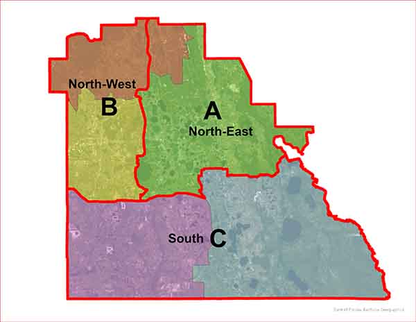
Description of Transportation Zone A
For a Point of Beginning, Begin at the intersection of US 98/State Road 35/Broadway Avenue locally, and Main Street West; Thence North along said US98/State Road 35/Broadway Avenue locally for approximately 1.1 miles to the intersection of Lyle Parkway; thence East along said Lyle Parkway to the intersection with Fort Fraser Trail; Thence South Easterly along said trail to the intersection with Old Bartow/Eagle Lake Road; thence North Easterly along said road for approximately 1.4 miles to the Intersection with Ernest Smith Boulevard; thence Northwesterly along the centerline of Ernest Smith Boulevard to the intersection with the extension of the Western shoreline of Lake Hancock and Saddle Creek Canal; thence Northerly along said Westerly shoreline for approximately 6.5 miles to the intersection with Saddle Creek; thence Northerly along said Creek for approximately 0.85 miles to the intersection with The Polk Parkway/State Road 570; thence Easterly and Northerly along said Polk Parkway/State Road 570 for approximately 11.2 miles to the intersection with Interstate 4/State Road 400; thence Easterly to the intersection with Mount Olive Road; thence Northerly and Westerly along the centerline of said road for approximately 1.2 miles to the intersection with State Road 33/ Commonwealth Avenue; thence Northerly along State Road 33/Commonwealth Avenue for approximately 16 miles to the Polk County, Florida North County Line; thence along said Polk County Line the following 10 courses; 1: East for approximately 1.8 miles; 2: South for approximately 1.1 miles; 3: East for approximately 8.1 miles; 4: South for approximately 6.1 miles; 5: East for approximately 6.1 miles; 6: South Easterly for approximately 4.5 miles; 7: South for approximately 4.0 miles; 8: East for approximately for 4.2 miles; 9: South for approximately 4.0 miles; 10: East for approximately 6.8 miles to the westerly shoreline of an unnamed canal; thence south easterly along said westerly shoreline for approximately 0.15 miles to the intersection with a Creek known as Dead River; thence following the center of said creek in a southerly, westerly, and southerly directions for approximately 7.5 miles to the easterly shore line of Lake Hatchineha; thence North Westerly along said easterly shoreline; thence westerly along the northerly shoreline; thence south easterly along the westerly shoreline of said Lake to an intersection with Catfish Creek; Thence Southwesterly, Southerly, Southwesterly, and Westerly along said Catfish Creek for approximately 7.5 mile to the south east shoreline of Lake Pierce; thence along the Southerly shoreline of Lake Pierce for 2. 7 miles to a point at the southeast corner of a parcel described in Official Records Book 12358 Page 02084 as recorded in the Public records of Polk County, Florida; thence along the southerly boundary of said parcel for approximately 995′ feet to the centerline of Masterpiece Road; thence westerly along the centerline of Masterpiece Road for approximately for 3.6 miles to the intersection with Scenic Highway North/State Road 17; thence North along Scenic Highway North/State Road 17 for approximately 1.2 miles to the intersection with Waverly Road; thence westerly along the centerline of Waverly Road for approximately 2.3 miles to the intersection of US 27 and Cypress Gardens Boulevard; thence west on Cypress Gardens Boulevard for approximately 1.8 miles to the intersection with Lake Ruby Drive West; thence South, Southwest, West and South along the centerline of Said Lake Ruby Drive West for approximately 1.7 miles to the intersection with Eloise Loop Road; thence West along said Eloise Loop Road for approximately 0.5 miles to the intersection with County Road 653; Thence South along the centerline of said County Road 653 for approximately 2.7 miles to the intersection with Old Bartow Lake Wales Road; thence West along said road to the intersection for approximately 0.50 miles with the CSX railroad crossing; thence Southeasterly along said CSX Railroad for approximately 1.8 miles to the intersection with State Road 60; thence Westerly along the centerline of State Road 60 for approximately 10.2 miles to the intersection with Flamingo Drive; thence Southwesterly along the centerline of said Flamingo Drive for approximately 0.50 miles to the intersection with Main Street East; thence West along the centerline of Main Street East for approximately 1.05 miles to the intersection with US 98/State Road35 Broadway Avenue locally and the Point of Beginning.
Description of Transportation Zone B
For a Point of Beginning, Begin at the intersection of State Road 60 and the West County line of Incorporated Polk County Florida; thence North along said West County line for approximately 17 miles; thence West along said West County line for approximately 3 miles; thence North along said West County line for approximately 6 miles; thence East along said West County line for approximately 3 miles; thence continue North along said West County line for approximately 3.6 miles to the intersection with the center of the Withlacoochee River; thence following the center of said river in an Easterly direction for approximately 7 miles to the intersection with the West section line of Section 18 Range 24 East Township 25 South; thence North along said West section lines of Section 18, section 7 Range 24 East Township 25 South and the West line of Section 6 Range 24 East Township 25 South to the North section line of said section 6; thence East for approximately 6 miles along the North Section lines of sections 1-6 Range 24 East Township 25 South to the West Section line of Section 31 Range 25 East Township 24 South; thence North along the west section line of said Section 31 for approximately 1 mile to the North section line of said Section 31; thence East along the North section line of Sections 31 and 32 Range 25 East Township 24 South for approximately 2.25 miles to the Centerline of State Road 33; Thence south along said centerline of State Road 33 for approximately 16 miles to the intersection with Mount 0 live Road; thence Easterly along the centerline of Mount Olive Road for approximately 1.2 miles to the intersection with the centerline of Interstate 4/State Road 400; thence Southwesterly along said centerline to the intersection with the Polk Park way/State Road 570; thence southerly along said Polk Parkway/State Road 570 for approximately 11.2 miles to the intersection of Saddle Creek; Thence southerly along said Creek for approximately 0.85 miles to the North shoreline of Lake Hancock; thence southwesterly and southerly along the western shoreline of said Lake Hancock and Saddle Creek Canal for approximately 6.5 miles to Ernest Smith Boulevard; thence Easterly and South Easterly along said road to the intersection with Old Bartow/Eagle Lake road; thence southwesterly along said road for approximately 1.4 miles to the intersection with the Fort Frasier Trail; thence Northwesterly along said Fort Fraser Trail to the intersection with Lyle Parkway; thence west along said Lyle Parkway to the intersection with US 98/State Road 35/Broadway Avenue North locally; thence south along said road for approximately 1. 1 miles to the intersection with Main Street West; thence west along said Main Street West for 0.70 miles to the intersection with State Road 60N an Fleet Drive Locally; thence West along State Road 60 for approximately 13.3 miles passing through the City of Mulberry, Florida to the Point of Beginning.
Description of Transportation Zone C
For a Point of Beginning, Begin at the South West comer of Incorporated Polk County, Florida County Line; thence North along the West Polk County, Florida County line for approximately 19.4 miles to the intersection with State Road 60; Thence east along the centerline of State Road 60 for approximately 13.3 miles passing through the City of Mulberry, Florida to the intersection with Main Street West; thence continue east along the centerline of Main Street West for approximately 0.70 miles to the intersection with US98/State Road 35/Broadway Avenue Locally; thence continue east along the center line of Main Street East for 1.05 miles to the intersection with Flamingo Drive; thence North East along the centerline of Flamingo Drive for approximately 0.50 miles to the intersection with State Road 60; thence Easterly along the centerline of State Road 60 for approximately 10.2 miles to the intersection with the CSX Railroad; thence North Westerly along said railroad for approximately 1.8 miles to the intersection with Old Bartow/Lake Wales Road; thence East along the centerline of said road for approximately 0.50 miles to the intersection of County Road 653; thence North along the centerline of said road for approximately 2. 7 miles to the intersection with Eloise Loop Road; Thence East along the centerline of Said road for approximately 0.50 miles to the intersection with Lake Ruby Drive West; thence North, East, North East and North along the centerline of said road for approximately 1.7 miles to the intersection with Cypress Gardens Boulevard; thence East along the centerline of said Road for 1.8 miles to the intersection with U.S 27; thence continue Easterly along the centerline of Waverly Road for approximately 2.3 miles to the intersection with Scenic Highway North/State Road 17; thence South along the centerline of said road for approximately 1.2 miles to the intersection with Masterpiece Road; thence Easterly along the centerline of said road for approximately 3.6 miles to the westerly extension of the south property line of a parcel described in Official Records Book 12358 Page 02084; thence Easterly along said south property line for approximately 995′ feet to the South West shoreline of Lake Pierce; thence along the southerly shoreline of said lake for approximately 2.7 miles to the intersection with Cat Fish Creek; thence Easterly, Northeasterly, Northerly, and Northeasterly for approximately 7.5 miles to the Westerly shoreline of Lake Hatchineha and the Easterly County Line of the Incorporated Polk County, Florida; thence Southeasterly along the Westerly shoreline and the Easterly Polk County, Florida County Line for approximately 27 .8 miles to the westerly Shoreline of the Kissimmee River; thence Continuing Southerly along the Easterly Polk County, County Line and the Westerly shoreline of the Kissimmee River for approximately 4.3 miles to the Northerly shoreline of Lake Kissimmee; thence continuing southerly along the Easterly Polk County, County Line and the Westerly Shoreline of Lake Kissimmee for approximately 20.2 miles to the Westerly shoreline of The Kissimmee River; thence continuing Southerly along the Easterly Polk County, Count Line and the Westerly shoreline of The Kissimmee River for approximately 12 miles to the Extreme South East corner of The Polk County, County Line; thence West along the South Polk County, County Line for approximately 56.5 miles to the Extreme South West corner of the Polk County, County Line and The Point Beginning.
Codes, Ordinances and Statutes
Forms and Documents
- Add Contact to Existing Permit
- Agricultural Exemption Affidavit
- Associated User Form
- Change of Primary Contractor
- Concrete Driveway Paver Release Form
- Contractor Change Request
- Expired Permit Notice and Extension Renewal Request
- Green Swamp Verification Form
- Non-Conversion Agreement
- Notice of Commencement
- Notice to Building Official
- Owner Builder Disclosure Statement
- Owner Builder Flood Hazard Notice
- Owner Builder Pre-Power Request Form
- Permitting and Plans Review Guide
- Public Record Exemption Request
- Revision to Construction Plans and Documents
- Roof Affidavit
- Temporary Shelter Affidavit
- Window Doors Affidavit
Contractor Licensing
Mobile Home
Utilities Code - Standards and Specifications
Navigate to the county’s e-Newsletter page to register for future updates to the Utilities Code and reference manuals. Once you have created your login, complete your contact information and select Utilities under Your Interests. This will ensure that you are notified of any future updates to the Utilities Code as a registered holder of the documents pursuant to Ordinance 10-081.
- Utilities Code Enacting Ordinance 10-081
- 6A Administration Manual
- 6B USSM Chapter 0 Table of Contents
- 6B USSM Chapter 1 General Information
- 6B USSM Chapter 2 Development Coordination
- 6B USSM Chapter 3 General Requirements
- 6B USSM Chapter 3 General Requirements Standard Drawings
- 6B USSM Chapter 4 Potable Water
- 6B USSM Chapter 4 Potable Water Standard Drawings
- 6B USSM Chapter 5 Wastewater
- 6B USSM Chapter 5 Wastewater Standard Drawings
- 6B USSM Chapter 6 Reclaimed Water
- 6B USSM Chapter 6 Reclaimed Water Standard Drawings
- 6B USSM Chapter 7 SCADA Standards
- 6C Cross Connection Control Policy Manual
- 6D Reclaimed Water Policy Manual
- 6E Industrial Wastewater Pretreatment Policy Manual
- 6F Water Conservation Manual
- 6G Fats Oils and Grease Policy Manual